

Editor’s Note: This story was originally published by ecoRI. Republished with permission.
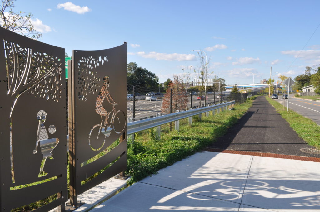
Highway traffic flows just below the new shared-use paths built in Federal Hill between Tobey and Waverly streets. Cyclists and pedestrians are enjoying their new separate lane, but should they be concerned about the polluting cars below?
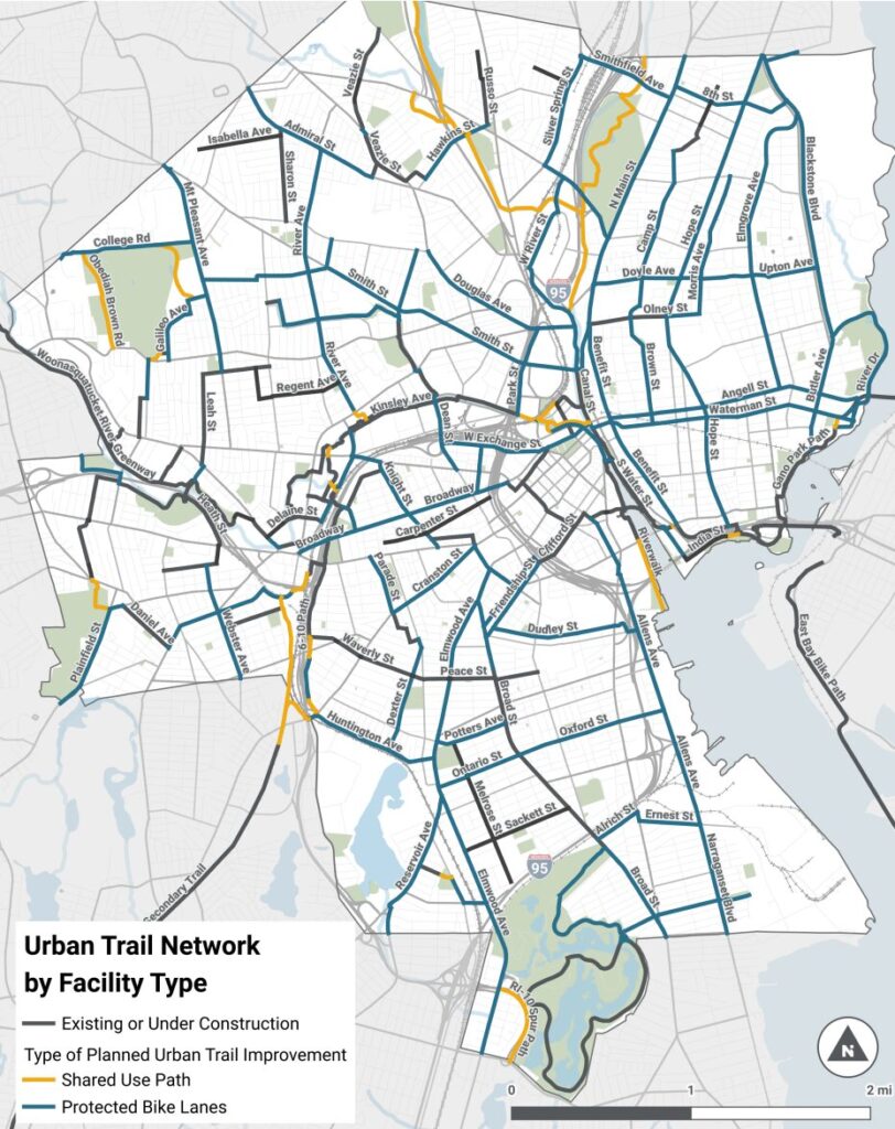
The new shared-use path is the latest addition to Providence’s urban trail network, a series of infrastructure projects designed to make walking and cycling safer and more accessible across the city. This particular 4,000-foot section runs parallel to the Route 6/10 Connector where cars, the largest source of airborne pollutants in the state, dominate. But air quality experts, city officials, and transit advocates agree: the benefits of using the path outweigh any risk the pollution may present.
“The urban trail network seeks to connect Providence’s 25 neighborhoods through high-quality alternative transportation infrastructure, ultimately linking up the state’s existing bike path network throughout the city,” said Michaela M. Antunes, Providence’s director of communications and economic development. “This project seeks to connect the existing Washington Secondary bike path from its trailhead in Cranston into the bike network in Providence, ultimately connecting through the new 6/10 bike path into the Woonasquatucket River Greenway.”
Antunes said the lane construction connecting a city trail extension to the Washington Secondary is funded through a federal Department of Transportation Safe Streets and Roads for All Grant and must be completed by 2028. City officials are collaborating with their counterparts in Cranston, where the Washington Secondary approaches the Providence border, but the teams have not yet developed a plan for paths to safely traverse the busy intersection of Cranston Street and Huntington Avenue.
“This is an ongoing conversation,” Antunes said. “Portions of this connection may be a combination of on-road or off-road based on multiple factors of feasibility.”
Dylan Giles has already used the newly constructed path a number of times, but said it will be more useful when the planned connections are complete. Giles is an advocate with the Providence Streets Coalition, an organization formed to support the city’s Safe Streets For All plan in 2020. As a car-free Rhode Islander, Giles needs transportation alternatives to go to work and get groceries, and he sees the 6/10 path as a step to improving connections in Olneyville, Broadway, and the West End.
“This will be valuable for so many different users, whether it’s someone in Cranston who can more easily access a job in Providence, or a family living in the West End who wants to go on a long weekend ride on a comfortable and safe facility,” said Giles, who remembers PVD Streets actually asked RIDOT for a much different plan for the 6/10 connection. Despite the state building what he calls “the least ambitious option,” Giles is grateful the new construction now features increased biking connections. “Often the path of least resistance is the only way to make progress, and in this case that means a path built on the banks of a highway.”
Sections of the East Bay Bike Path and the Woonasquatucket River Greenway also run parallel to major roads, Interstate 195 and Route 6 respectively. Using these paths brings users in close proximity to motor vehicles distributing their fair share of pollutants.
“Alongside the highway in Rhode Island, our biggest air quality issue is from transportation. We don’t have a ton of industry here anymore,” said Darren Austin, a meteorologist with the Rhode Island Department of Environmental Management. Austin, who manages the air quality alerts in the state, said the wind blows air pollution to Rhode Island from other parts of the region, but locally, the constant presence of cars is what spews the most toxins.
“When talking about traffic, you’re talking ultrafine particles,” he said. “You’re dealing with gases from combustion, like nitrogen oxide, some [volatile organic compounds]. And then you get into diesel with trucks, you have black carbon. You have fine particles, ultrafine particles. You have brake dust, tire wear.”
The Rhode Island Department of Health tracks asthma rates across the state, and hot spots track right along Route 10 and Interstate 95 in Providence, Cranston and Pawtucket. However, environmental justice communities may also suffer from poor quality of housing or may be facing other environmental hazards outside of the highway constructed in their neighborhood. Fresh Air Providence, an initiative by RIDOH’s Asthma Control Program, is measuring indoor and outdoor air quality in zip codes 02905, 02907, and 02909. Findings from that study should be available in 2026.
So, should residents be anxious about breathing toxic fumes while on their bike rides overlooking the traffic? According to Austin, there’s no perfect answer.
“As soon as you talk air quality, it gets complicated very quickly,” he said. “If you’re just riding a bike through there a few minutes a day, that’s very different than living next to the highway.”
The first factor to consider, Austin said, is wind direction. Usually, the jet stream blows wind from west to east through Rhode Island. An in-depth study of air quality around I-95, with measuring stations in Cranston, Pawtucket, and Providence, found the highest levels of black carbon and ultrafine particles in the air when the stations were downwind of the highway, during morning rush hour and high traffic times, and when wind speed was low. The built environment also will affect pollution flows near the new bike path, which runs parallel to the highway, separated only by a fence and a few feet of grass between Waverly and Westminster streets, but which towers more than 30 feet above the highway on constructed walls from Broadway to Tobey Street.
“When you’re driving right through the city, like by Broadway, there’s hills on both sides of you. They call that canyoning,” Austin said. “A lot of times, the pollution will stay in. It kind of gets trapped a bit in the canyons.”
Antunes said the city will continue to plant more trees and add buffers along the shared-use path to minimize pollution as funds allow. Advocates, administrators and researchers all agree the benefits of new biking infrastructure outweigh the impact of local pollution. By encouraging healthy physical activity and replacing motor vehicles, they hope projects like this will put the city on the path to healthier, greener Providence.
“Despite all of the tradeoffs, the 6/10 path is a good thing,” Giles said. “It is another option in a place without many and another step forward in creating a connected network for everyone.”
Want to comment? Click!