
Editor’s Note: This article was originally published by Providence Post on December 18, 2025. Copyright ppsri.org. Reprinted with permission.
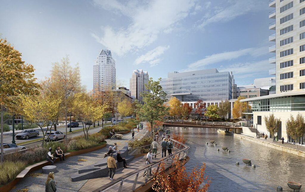
How the area may transform, the latest engagement meeting on the Providence Riverwalk Resilience Project
Since the 1990s, the Riverwalk and Waterplace Park have become cultural mainstays of downtown Providence, thanks in part to the fact that Waterfire has become such a key part of residents’ and visitors’ traditions.
But today, this infrastructure is seeing some challenges related to flooding and accessibility. The City, in partnership with Arup US, launched a process to reenvision the future of the area in the summer of 2024.
Recently, the third public meeting (of more to come) was held to ask residents for design feedback and suggestions for the area. Over 30 residents attended the latest engagement session on Thursday, Dec. 11, at 444 Westminster Street. Participants ranged from high school students to retirees, and live translation services were provided during the meeting for Spanish-speaking residents.
Project Goals, per the City
- Create a new ADA-accessible shared use path that is safe for people of all ages & abilities between Francis & Steeple streets.
- Create seven new ADA access points to the Riverwalk.
- Improve connectivity with surrounding streets to improve public safety & accessibility.
- Raise the new shared use path & Riverwalk above future flood elevations.
- Address structural deficiencies in sections of Riverwalk walls that will remain.
- Replace the pedestrian bridge over the river at Waterplace to make it ADA- & bike-accessible.
- Replace flooded, unsafe pedestrian tunnels with a new bike/ped bridge to connect the Riverwalk to Kennedy Plaza (the City’s central civic plaza & transportation hub) & catalyze private development.
- Create safe new crosswalks for people walking & biking across Memorial Boulevard & Exchange Terrace.
- Install adaptive signal control technology along Memorial Blvd to adjust signal timing to accommodate changing traffic patterns, improve travel time reliability, reduce congestion, & reduce emissions.
- Filter stormwater runoff that currently runs into the river from surrounding streets.
- Install new wayfinding & interpretive signage to improve navigability for people walking & biking.
- Demolish hardened riverwalk walls between Waterplace & Steeple Street.
- Naturalize riverbanks beneath the raised shared use path to improve water quality, resiliency, & habitat.
The meeting was facilitated by CIVIC, and the lead firm on the project — Arup — presented the latest designs. Worksheets were distributed for attendees to fill out where they could note their connection to the area, what they hope to see, considerations of the natural environment, and other suggestions for the project. Public officials and designers on the project described this initiative as the next phase of major infrastructure projects in the area, with Waterplace’s original creation coming about after the city moved rivers, railroads, and later, a highway, to open up space around Downtown.
“This is a multi-faceted attempt to look at strengthening our infrastructure, improving accessibility for all users, to look at ways to enlighten, invigorate and energize this area, and to make adjustments along the edges,” Director of Planning and Development Joe Mulligan said at the top of the meeting. “When the original project was done, they did what they could do with the resources that they had. And it’s incumbent upon subsequent generations to take that idea and all that excellent infrastructure and continue to refine it, enhance it, and improve it so that it reflects the needs and desires of the folks who use it now and will in the future.”
Here are some takeaways from this latest meeting.

1. With the frequency of flooding, the Riverwalk will be adapted to improve resiliency. Some sections of the Riverwalk are proposed to remain — some will be “rewilded.”
One side of the walkway along the river is raised slightly higher and does not flood, and as such will remain accessible and walkable. But the other side of the river is slightly lower and will be “rewilded” to reintroduce native plants and vegetation while a raised platform will be created to accommodate foot traffic.

“The general idea that we’re also trying to implement here is the rewilding of the area we have somehow,” Alban Bassuet, associate principle for Arup, said. “We have to create higher platforms for people to walk, because it floods, and so the existing Riverwalk will remain, but the idea is to cover them with soil and vegetation, and that vegetation can grow from underneath.”
The cobblestone featured throughout the waterfront park area will be swapped for a smoother surface, to make it more accessible for wheelchairs, strollers, and other modes of transportation.
Bassuet added that there will be a kayak launch as well as various “nooks” where people can sit and gather along the parkway.


2. Memorial Boulevard could be narrowed to increase sidewalk size and pedestrian activity while slowing down traffic.
“We are also going to reduce the width of the lanes on Memorial Boulevard, and that’s going to give us quite a lot of space to create a new street experience above the Riverwalk,” Bassuet said.
Bob Clinton from the firm VHB spoke about how drivers often treat Memorial Boulevard like a highway off-ramp. “The project includes traffic calming measures in an effort to reduce the travel speeds along Memorial Boulevard and make it better accommodate all users,” Clinton said. “So some of these measures that we’re going to introduce are… reducing the travel lanes, introducing landscaping, which kind of gives that tunnel effect so drivers tend to slow down when they experience those types of features.”

3. Designers are hoping to increase pedestrian connectivity with Kennedy Plaza and Downtown through the Riverwalk area.
A pathway designers described as the “downtown connector” would connect Burnside Park and Kennedy Plaza to the Riverwalk area, which would be a new crossing for pedestrians.
4. Participants and planners alike were excited by the prospect of connecting the various waterfront parks around Downtown.
Several attendees mentioned the possibility of creating a network of waterfront greenspaces, adding access points between this new Riverwalk, the 195 Park, and eventually Collier Point Park on the Southside, which can only be accessed off the highway.
“I think I’ve heard this mentioned before, but what’s next once this is completed, [is] the connection between here, 195 Park, but then also Collier Point further down and the Port,” planner Chris Martin said at the meeting.

5. Safety, lighting, and programming are a top priority to keep the area populated.
Increasing activity in the area was discussed not only as a programmatic and cultural benefit, but also as a way to ensure safety. Dynamic lighting, with features that can change colors based on the event, also was mentioned.


6. The timing on this will depend on federal funding options — but the City wants to have a project shovel-ready just in case.
Though planning is underway already, officials don’t have a sense of when execution and construction on the project will actually begin.
“The work that we will do here tonight will lead to plans and specifications that will be ready to go right when the moment occurs,” Mulligan said. “The challenge is particularly in today’s financial constraints, particularly at the federal level, we’re not exactly sure when that occasion will occur. So in a way, we’re planning for what we would like to see today, with the hopes that we can achieve it.”
“Construction will be dependent on sourcing federal funding,” according to the project website.

Correction: A previous version of this story stated that lanes from Memorial Boulevard were going to be removed, not narrowed. The Post regrets the error.
Want to comment? Click!