

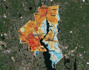

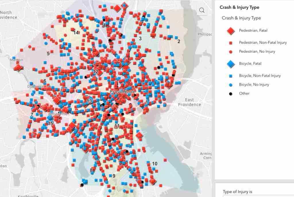
A new interactive data and mapping initiative from the Providence Streets Coalition (PSC) is now available to the public, giving both residents and officials a block-by-block visualization of every reported motor vehicle crash involving a person walking or bicycling since 2010. The interactive map pinpoints and details more than 3,600 crashes in the City of Providence in a 13 year timeframe, and reveals the many dangerous areas and alarming trends facing non-drivers within the City.
Key takeaways from the new initiative include:
- 2022 was the deadliest year for pedestrians since 2016
- 30 people were killed by motor vehicles on Providence streets since 2010
- 3,678 pedestrians and cyclists were hit by motor vehicles since 2010 (2% of Providence’s population)
- 88% of crashes resulted in injuries or fatalities
- 40% of collisions occurred at signaled intersections
- 28% of crashes were hit-and-run
- The census block containing three of Providence’s high schools (PCTA, Central, and Classical) had the highest amount of crashes in the city
“I am so appreciative of the hard work to create this tool from the Providence Streets Coalition,” said Providence City Councilor Sue AnderBois. “We will now be able to better use data to drive policy and practices to improve the safety of our residents on our streets and sidewalks. Safely navigating city streets and sidewalks using whatever mode of transportation you prefer is non-negotiable quality of life issue in Providence. I will use this data regularly in Ward 3, especially as we move forward with the North Main Street Task Force.”
The data does not include the two pedestrian fatalities on North Main Street that have occurred in 2023. Providence Streets Coalition volunteers will update the map on an annual basis each spring.
“Every one of the dots on this map represents a human life that has been changed or ended as a result of traffic violence,” said Liza Burkin, PSC lead organizer. “This isn’t something that we accept as an inevitable outcome of the road network that we have built.” The map confirms much of the findings of the city’s High Injury Network which show the top dangerous intersections and corridors throughout the City.
The initiative is the result of ongoing efforts by PSC to access critical street-level data on incidents of traffic violence involving pedestrians and cyclists. The source data for this project were provided by the City of Providence in response to public records requests under APRA (Rhode Island’s public records law). Similar data being sought from the RI Department of Transportation (RIDOT) have been denied (see adjoining PVD Eye story) although the City’s data does include crashes that occurred along state-maintained roads.
“Open access to traffic safety data is critical to a community understanding their transportation challenges and developing strategies to address them,” said Eric Jackson,
Executive Director of the Connecticut Transportation Institute and an advisor to the project. “Tools to support understanding and knowledge should be available to those interested in making a difference. The data collected, maps generated, and analysis conducted should drive our decisions to improve safety for all road users, with a priority on our most vulnerable.”

The monumental effort to assemble and clean more than a decade worth of reports was led by a team of dedicated volunteers who painstakingly cataloged and mapped data obtained from the City. “By bringing this information to the surface we hope to inform and inspire action to build streets that are safe for everyone, no matter your mode of choice,” said Derek Wietsma, one of the project leaders, adding, “Ultimately this project is about a bunch of volunteers coming together to make our city and communities safer.”
GET INVOLVED: The Providence Streets Coalition is an alliance of 42 community organizations, local businesses, schools, neighborhood associations, and thousands of engaged individuals advocating for people-friendly streets in Providence. See pvdstreets.org
Want to comment? Click!